A Walk to the Beach – Sandwood Bay!

The national UK forecast from London declared the 2013 July heatwave had arrived and the whole country would be bathed in glorious sunshine. Meanwhile back in the North West Highlands we had a serious storm force wind problem. After being blown over on Cul Beag the previous day, it had sounded like the guesthouse roof was coming off during the night. There was little point in trying to get up hills, so we drove north to visit the most remote beach in mainland Britain, Sandwood Bay.

Instead of the usual ‘out & back’, this route adds a circuit along the cliffs to the Am Buachaille sea stack. This can be done on the walk-in, or as we did on the return.

  • Distance = 10.3 miles (16.58 km)
  • Duration = 5 hrs, start 1.00pm & finish 6.00pm, inc time on beach etc
  • Total Ascent = 1,440 ft (440 m), max height 442 ft (135 m)
  • Start/Finish = maintained car park (with toilets) near Blairmore
  • Conditions = strong winds, very hazy, dry, cloud inland affecting distant views
  • Date = Friday 5th July 2013
Sandwood Bay Location

Sandwood Bay Location

Sandwood Bay Route Map

Sandwood Bay Route Map, click on map to zoom in

Sandwood Bay is located in the far north west tip of Scotland and is 4 miles from the nearest single track road. We drove up from Ullapool, which is a very pleasant drive in itself, in fact we nearly didn’t make it after seeing mighty Quinag; only the extreme winds put us off an ascent. The starting point for Sandwood Bay is a car park just past Blairmore, (north of Kinlochbervie). Walk across the road to a track by the side of cottage where a handy ‘Sandwood’ sign points the way. The track goes through a gate heading initially north east past firstly Loch Aisir then Loch na Gainimh before straightening northwards. The area is managed by the John Muir Trust and progress is swift along a surprisingly good level path through fairly bleak moorland. Unfortunately the hazy light wasn’t ideal and I managed to accidentally reduce my phone camera resolution, so the pics aren’t too sharp.

40mins along the path to Sandwood Bay, by Loch a Mhuilin

After 40mins swift walking along the path to Sandwood Bay, by Loch a Mhuilin

There’s little to see on the four mile walk in, so it’s really just a case of cracking onwards knowing that the landscape will soon open up and it will all be worth it. Most people go straight to the beach however we recommend doing the above route in reverse, which means turning off the path next to Loch Clais nan Coinneal and heading north west straight to Am Buachaille. We didn’t know this at the time so continued on past the Loch where you soon get your first view of Sandwood Bay ahead.

After 65 mins the first view of Sandwood Bay

After 65 mins the first view of Sandwood Bay

Rather than head straight down to the beach we made a short diversion in the opposite direction to the ruined bothy of Sandwood House. This is reputedly haunted by the ghost of a bearded sailor who drowned when a Polish ship was wrecked in the bay. In fact there’s a few ghostly stories associated with the area not that we noticed anything unusual, apart from the odd headless horseman.

Diversion to the haunted ruined bothy of Sandwood House

Diversion to the ruined bothy of haunted Sandwood House

From the ruin it’s a short walk west to a small hill for a great view of the Bay.

Sandwood Bay panorama

Sandwood Bay panorama from a hillock

Sandwood Bay

Panorama further north

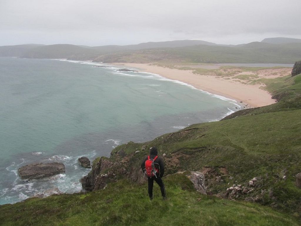
After a short descent over grass, you weave through sand dunes which suddenly open out on to one fine stretch of beautiful beach. It’s an impressive moment as the whole open panorama opens up around you. Being labelled the “remotest beach” means  it’s unlikely you will be alone here, not that it’s a problem but it would make it even more special.

On the beach

Finally on the beach

Sandwood Bay

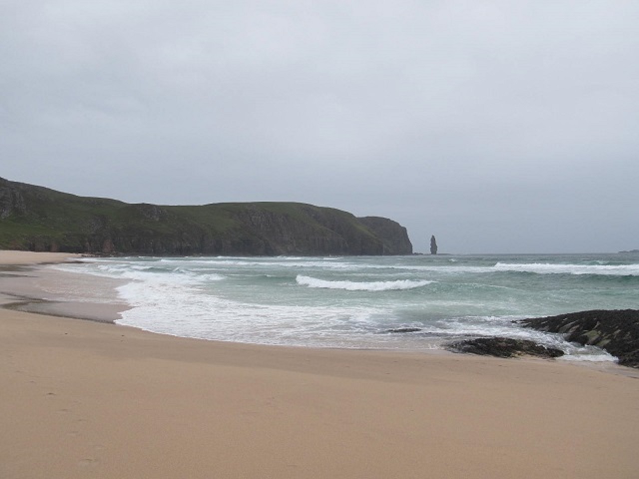
View along Sandwood Bay coast to the sea stac of Am Buachaille

This is where it gets a bit embarrassing, the only excuse is me & my mate Alan are in our fifties and we get confused with names sometimes, me particularly. Anyway earlier in the week I’d been calling the place Sandalwood for some reason, but had been using the correct name all day. Until Alan started calling it bloomin Sandalwood too. So what should have been a memorable photo below was deemed unusable once I checked the pics later 🙂

What could have been a wonderful photo

What could have been a wonderful photo

No sand was hurt in the making of this photo, and it was all brushed out in readiness for the incoming tide. We nipped onto some rocks to sit and stare at the waves and views. This is a great area for Dolphins and seals etc however after half an hours scanning with binoculars I didn’t see a thing. Half an hour seems to pass very quickly here so do leave yourself lots of time to enjoy and explore, there’s plenty of beach to wander around.
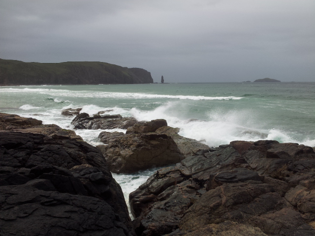
20130705_150051

On the rocks

20130705_150130

View north to the far edge of mainland Britain

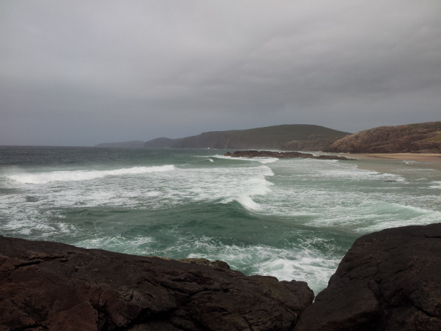
On the horizon above the most distant cliffs could be seen the white top of a lighthouse. Through binoculars we discovered this was Cape Wrath the most north westerly point on mainland Britain. Somewhere I’ve always wanted to see and somehwere I wasn’t expecting to see from here. Nice place for gazing is Sandwood however the tide was slowly advancing so we left the rocks rather than be marooned and started walking south along the soft golden Sandwood sands.

Sand tracks

Sandwood tracks

20130705_152314

More Sand

Sandwood 2

Even more sand

Sandwood

Am Buachaille from near the cliffs

We didn’t want to just return the same way and had spotted a path leading above the cliffs which just had to be checked out. Sure enough it gently rose from the beach and followed the cliffs with super views down to the sea and back to Sandwood. It gives a different perspective on the scenery and is hugely recommended.

Starting the cliff walk

Starting the cliff walk

Sandwood Beach

Beach

Sandwood Beach

Getting Higher

Sandwood Bay_1

Lingering looks back to the beach

Am Buachaille

Getting nearer to Am Buachaille

Eventually the path leads to a point overlooking the sandstone sea stack of Am Buachaille. You can see climbing ropes and it was first climbed by Tom Patey & Ian Clough in 1968. The climb involves a short swim and looks absolutely ridiculous, the whole stack seems worryingly weathered, however here’s a link to some crazy climbing on Am Buachaille.

Am Buachaille

Am Buachaille

Am Buachaille

Am Buachaille & Boots, for no reason

From here we headed south-east over moorland, carefully rounding some boggy areas to eventually rejoin the main Sandwood path. Make for the low point on the south side of Druim na Buainn which is easily kept in view as it’s the high point of the area & has a small cairn. We found the odd boot mark but there isn’t really a path to follow. You rejoin the main path at the south west edge of Loch Clais nan Coinneal passing a large isolated wooden fence post. This is definitely a route worth doing in reverse so at the start of the Loch head north-west past the fencepost straight to Am Buachaille, then walk along the cliffs to the beach, (click on the route map at the top).

The path seemed longer on the way back to the car (as they often do) . A great afternoon despite the windy hazy weather. There was still time too for another diversion…..

Oldshoremore Beach

When researching Sandwood a few mentions were made that nearby Oldshoremore Beach was worth a visit. I’d had a couple of Tweet recommendations too saying whilst less remote it’s almost as spectacular and far less popular than Sandwood. So we diverted very quickly for a dash to the sand and back. You can park 200yds from the beach and it definitely is highly recommended, deserving more time with calmer weather than we had. PS; I can’t stop calling this one Oldmoreshore, which sounds more sensible to me, possibly 🙂

Oldshoremore Beach

Oldshoremore Beach, 6.30pm

Oldshoremore Beach

Oldshoremore Beach

Oldshoremore Beach

Oldshoremore Beach

On the drive back to Ullapool we wanted to try the Kylkesku Hotel for food. It’s situated close to the award winning Kylesku Bridge which opened in 1984. Previous to this you had to get a ferry from a crossing by the hotel!

20130705_194359

Kylesku Bridge

We had already called at the hotel earlier on the drive up to Sandwood to suss it out. The bar & beer choice looked good with a decent menu, though extremely quiet. It certainly wasn’t quiet when we arrived for tea though, it was absolutely heaving with cars parked everywhere. Indeed we were very lucky to get a table, disappointingly in the boring restaurant rather than the lively bar. Alans chicken was good, my Sole in parchment bag too boney for me. Nice pint of An Teallach though & a lovely spot.

Dinner at the Kylesku Hotel, mine wrapped in parchmenty stuff

Dinner at the Kylesku Hotel, mine in parchment

On rejoining the road from the hotel, the wonderful Quinag dominates the horizon. We were tempted by this earlier but agreed it had been too windy & cloudy today.

The fascinating Quinag

The fascinating Quinag

The light was now really starting to improve with the lowering sun turning things into a clear Highland evening. As the sun started to set we couldn’t resist making one final diversion at the Ardvreck Castle car park, This had been full of tourists earlier, now it was just us, and the sunset was worth getting outta the car for 🙂 I’d managed to correct my phone camera settings for these and just pointed it at the sun.

Sun setting over Ardvreck Castle & the Quinag, 9.40pm

Sun setting over Ardvreck Castle & the Quinag, 9.40pm

Sun setting over Ardvreck Castle & the Quinag

Sun setting over Ardvreck Castle & the Quinag

There’s an interesting information board here on the history of the area. The castle is notable for holding the Marquis of Montrose in it’s dungeon before being hung, drawn & quartered in 1650. There’s 2 ghosts, murders, sieges and a mermaid, oh and more ghosts at nearby Calda House. We were fascinated by the story of the Duke of Sutherlands Grandson who built a 9 hole golf course here before the First World War. It was maintained by a local mans ‘grass cutting machine’ pulled by a pony. Guests would get a steamer from Loch Assynt Lodge to a jetty here for a round at a cost of one shilling per day. (See link at end)

Ardvreck Castle looking south, over the golf course!

Ardvreck Castle looking south, over the golf course!

Quinag Sunset

Quinag Sunset

Quinag Sunset

Quinag Sunset

Ardvreck & Quinag, looking like a cardboard cut out

Ardvreck & Quinag, looking like a cardboard cut out

A glimpse of the beautiful Suilven on the journey back

A glimpse of the beautiful Suilven on the journey back

Finally we got back to Ullapool & had a pint! Somehow we’d crafted a brilliant day sheltered from the storm force winds. The next day we wouldn’t be so lucky weather wise but still had an excellent adventure….

Posted in Scottish Highlands & Skye | Tagged , , , , , , , , , , , | 17 Comments

Return to Sutherland, Blown Over By Cul Beag!

Cul Beag is a 2,550ft Corbett in remote & beautiful Sutherland. The name in Gaelic means ‘Small Back’, a Corbett is a Scottish hill between 2500-3000 ft; and Sutherland is a long long way up north (the top left bit). This was the first day of our North West Highland holiday and due to 70mph storm force winds, it was a quick but eventful nip up & down.

  • Distance = 4 miles (6.5 km)
  • Duration = a slow 4 hrs 30 mins, late start at 12.30pm, finish 5.00pm
  • Total Ascent – 2,550 ft (777 m), max height 2,522 ft (769 m)
  • Start/Finish = near Linneraineach on north side of Loch Lurgainn
  • Date = Thursday 4th July 2013
Sutherland & the NW Highlands with Cul Beag route - click to zoom

Sutherland & the NW Highlands with Cul Beag centre – click to zoom

Cul Beag western approach route from near Linneraineach

Cul Beag western approach route from near Linneraineach

Back in the far north west Highlands at last after 25yrs! We arrived in Ullapool on a Wednesday evening in surprisingly good weather, which literally deteriorated during a meal at the Arch restaurant. Thursdays forecast had been poor all week, so Plan A was merely to drive up the coast and have a looky around. However come morning there was an unexpected hint of one of my favourite weather words, ‘improvement’. Unfortunately this was coupled with one of my least favourite weather words, ’70mph storm force winds’. Ok, I know that’s four words….all of them bad ones.

Morning view from Ullapool Guesthouse Window, with passing Stornoway Ferry

Morning view from our Ullapool Guesthouse window, with passing Stornoway Ferry. Windy!

Optimistically we packed for the hills, with the new Plan A being to drive east along the A835 and check out Ben Wyvis. Theory was it would probably be safe on Wyvis’s grassy slopes especially as the weather’s often better in the east. We stopped near Loch Glascarnoch to discover the east was far worse and Wyvis was completely shrouded in mist. We didn’t fancy lumbering over its featureless slopes in a misty gale, however above us were the Fannichs, which surprisingly were clear. So we started discussing possibilities, the only problem was every time we got out of the car, the extreme winds hit us. Agreement was quickly reached that it would be too exposed up there and that something smaller would be more sensible.

The brand new Plan A was to head back to Ullapool, drive north and walk up the first decent smallish mountain that looked clear. Ten minutes past Ullapool we came to the first decent smallish mountain, Ben More Coigach, which was covered in cloud. The next was Cul Beag which was clear, the third was Cul Mor which wasn’t. So we turned off west along Loch Lurgainn for Cul Beag, and soon saw a welcome sight that we hadn’t seen for a long long time, (no, not the blue sky).

Last seen 25yrs ago! Nice to know the wonderful Stac Pollaidh is still here!

Last seen 25yrs ago! Nice to know the wonderful Stac Pollaidh is still here!

The updated Plan A was to try and get up Cul Beag via the west approach, which gave the quickest route to the top and more importantly would provide shelter from the storm force winds, at least until the summit. Hopefully we would carry on in a clockwise circuit coming back down on the east side, then back along the road to the car. If the wind was too fierce then Plan B would be a forced retreat down by the ascent route. We drove slowly along the single track road until nearing Linneraineach we spotted what looked like the ascent route, a stalkers path on the right. We had to drive a little further to find a suitable parking spot by some trees. To keep up the optimistic theme I applied some aftersun followed by my Avon Skinsosoft midge repellant – neither would be needed, but my skin felt vibrant.

We weren’t too sure about the path as it started faintly, heading north without getting any nearer to the mountain. It then veered towards Stac Pollaidh & just as we thought we’d got it wrong it turned right again and we soon arrived at Lochan Fhionnlaidh with wondrous bumps ahead. We had seen Suilven before, but this was the first time perfectly clear.

20 mins after leaving the car, first ever fully clear view of enigmatic Suilven

20 minutes after leaving the car, first ever fully clear view of enigmatic Suilven

Suilven had been an enigmatic mountain since seeing it in books many years ago, so to see it again was actually quite emotional, big smiles all round. We stopped briefly to take some photos, noting that the weather ‘improvement’ seemed to be on hold. Despite some encouraging blue patches out to sea there were stubborn cloud banks hanging around inland. Luckily we were still sheltered from the worst of the wind and luckily Cul Beag was still clear, so we left the main stalkers path and turned east to start the ascent to the col.

Cul Beag, the route goes straight up to the dip, doesn't seem far

Cul Beag, the route goes straight up to the col, doesn’t seem so far

Professional mountain posing (note use of rock), looking sth west over Loch Lurgainn

Professional mountain posing (note use of rock), looking south west over Loch Lurgainn

More experienced mountain posing (found another rock), over Lochain to Stac Pollaidh

More expert mountain posing (found another rock), west over Lochan Fhionnlaidh to Stac Pollaidh

Big hairy Fox Moth caterpillar?

I’m told this is a Drinker Moth caterpillar

Clambering up became slow for some reason with the distance feeling longer, perhaps because our eyes were constantly drawn to the incredible cloud speeds racing over the summit above. As we reached the col the wind picked up, however this would only be a hint of what lay ahead as we were still on the sheltered north side. Above us lay the final steep section to the top which we ascended following a small zigzagging path upwards. Views back were still excellent despite the cloud having lowered on Suilven & Cul Beag. 25yrs ago we did Stac Pollaidh in mist & rain hardly seeing a thing, so today was already a triumph whatever the conditions ahead. We were very content just to stare wistfully at the scenes below.

Heading up Cul Beag with mighty fine views north over Assynt, (spot the rainbow)

Heading up Cul Beag with mighty fine views north over Assynt, (spot the rainbow)

View to right over Cul Mor, Suilven peaking left

View to the right, over Cul Mor with Suilven left

Little further up, looking west over Stac Pollaidh

A little further up, looking west again over Stac Pollaidh

Last lingering look before wrapping up to meet the summit winds

Last lingering look before wrapping up to meet the elements!

It all looks quite pleasant on the photos, but we could already hear the roar above us, so just below the summit plateau we stopped to add layers and zip up. The plan was to get to the top, suss it out and take no risks. It was interestingly windy on top, the summit cairn was reached immediately and we carefully dashed over for the necessary photos, then found a sheltered spot to leave walking poles and survey the views and preferred route down.

On the summit of Cul Beag, trying to look relaxed in storm force winds

On the summit of Cul Beag, trying to look relaxed in storm force winds

We managed to get near to the western edge to take photos by lying down & crawling. This needed a firm grip of the phone camera otherwise it would never be seen again!

Shaky view west from the top of Cul Beag, gripping phone tightly!

Shaky view west from the top of Cul Beag, gripping phone very tightly!

Meanwhile the wind was hitting the southern summit edge throwing cloud upwards at incredible speed & angles, making a deep & unnerving roaring sound. We’d been up in storm force winds before but this scene was something new, we couldn’t actually hear each other so started laughing, as you do. Occasionally gusts would rock us so we kept to level ground, me being the lighter svelte one seemed to be getting rocked the most. We decided to try to edge towards the south side but were soon bent double by the force and retreated. Views had been amazing until unfortunately the cloud came down, so we edged back to the sheltered spot to eat and discuss the descent options, hoping it would lift.

Sheltering at the not so sheltered spot near the summit looking east over descent Plan A

Sheltering at the not-so-sheltered spot near the summit, looking east over descent Plan A

The sheltered spot suddenly wasn’t so sheltered anymore and the cloud wasn’t shifting. Despite this we still fancied Plan A carrying on east to make a circular walk, but then it started to rain. The rain was horizontal, which would be in our faces and very exposed for a long time. It was getting worse and the wind stronger, we still hoped it was temporary however we’d been up here a while and it was starting to feel colder so we knew we had to start moving. We decided to descend slightly to start Plan A when a huge gust came in and bowled me forwards on a slope banging my knee and rolling me like an Italian footballer. Luckily I was wearing gloves and knee supports, yet the knee was grazed and it hurt! Alan had been knocked sideways at the same time. We called an emergency meeting, conditions really had worsened and had gone beyond fun, we decided to promote Plan B (RETREAT) with immediate effect. As quickly & as carefully as possible we located our descent route and picked our way down. The cloud had dropped more than expected and it took a while to drop out of the mist. All the time we had to be mindful of occasional sudden buffeting gusts which were problematic if they caught you off balance. As soon as we heard a gust coming we adopted a crouched position till it passed. Not once during this process did we regret our decision to retreat. As I mopped the blood from my grazed knee we were more than satisfied just to have made it to the top.

Out of the cloud & fearsome wind, Alan a dot descending rapidly

Out of the cloud & fearsome wind, Alan a tiny dot descending rapidly

Back at the car we gazed up at Cul Beag, it’s cloud had lifted again & all looked calm & serene, but we knew that the mountain was just waiting, waiting to snare it’s next victim:-)  My knee ached for 2 weeks and I didn’t whinge once as I was so brave (not). It served as another reminder to respect the wind, it’s serious & can catch you anytime. Cul Beag would be an excellent easy hill walk on a good day – and we didn’t see a sole, wonder why 🙂

Cul Beag from the parking spot, looking innocently calm

Cul Beag from the parking spot, impersonating innocent calm!

We drove the short distance to Ullapool in need of a celebratory pint and called in at the Morefield Motel (decent food reports on Trip Advisor). It was quietish though the bar looked good, so I asked the landlady what the locals drink and she said in a professional voice “Sheepshaggers”. Unfortunately I didn’t have any wellies so tried some of the ale instead, not bad, and the An Teallach tasted even better, best pint of the trip.

Morfields Motel Beer Choice, I tried the Sheepshagger & An Teallach

Morefield Motel Beer Choice, I tried the Sheepshagger & An Teallach

Check the pump badge on the left, it’s not an ale, they use it whenever a beer runs out, nice touch of humor 🙂  After a quick guesthouse freshen up, we found the Arch restaurant full so limped over to the Ceilidh Place, followed by a pint of Deuchars at the Ferry Boat. The winds had never eased and tomorrow looked similar. Meanwhile Alan had a plan…………… Day 2, A Walk to the Beach, Sandwood Bay.

Guesthouse window view Thursday evening 7.30pm

Guesthouse window view Thurs evening 7.30pm, after a satisfying first days adventures

Posted in Scottish Highlands & Skye | Tagged , , , , , , | 7 Comments

Warm Western Wainwrights – Whiteside, Hopegill Head, Grasmoor, Wandope, Whiteless Pike and Rannerdale Knotts

Long ago when I was a lad, we just used to choose a few classic Lakeland peaks and walk up em. Nowadays these bloomin Wainwrights have been invented, so now we have to go back & pick off all the surrounding peaks we managed to miss. This is really inconvenient but is luckily turning out to be immense fun. The route below added a few missing Wainwrights on a busy Sunday during a heatwave, and was also immense fun:-)  

  • Distance = 10.5 miles (16.9 km)
  • Duration = 7 hrs (inc a few long rests from the heat)
  • Total Ascent = 3,900ft (1,190m), max height 2,795ft (852 mtrs)
  • Start/Finish = Car Park on B5289 near Lanthwaite Green Farm NY159208
  • Date = 14th July 2013, start 11.30am, finish 6.30pm
  • Refreshments = none, so Kirkstile Inn, Loweswater after (recommended)
  • Click on Route Map below to zoom in/out
North Western Wainwrights Route

North Western Wainwrights route

Four days after returning from a walking holiday in the Highlands, we nipped over to the Lakes to bag a few Wainwrights and show off our newly heightened highly honed mountain fitness. Parking at Lanthwaite Green Farm car park on a gloriously sunny day, we had to start by slapping on lashings of ginger beer, I mean suncream. It was hot, it was bloody hot, but this didn’t matter as we had heightened highly honed mountain fitness. We set off at a fast pace, then after 15mins I was sweating & knackered. Even Alan was soon knackered. So much for our heightened highly honed bloomin mountain fitness:-)

Looking back over the ascent route, Melbreak, Loweswater & Low Fell

Looking back over the ferny ascent route, then Melbreak, Loweswater & Low Fell

In our keenness to get up, we crossed the impressive new bridge over the Liza Beck then went straight on northwards & up east through ferns. In fact we should’ve just turned right once over the bridge and followed the skyline over the Whin Ben. I’ve amended the map to shows the correct route however if you like ferns then do take our initial route:-) After 50 minutes of sweaty slog, taking any excuse to rest & admire the views, we were back on course. The proper path can be seen over the Whin Ben below.

A man with highly honed mountain fitness and Crummock Water & Mellbreak

Notice my heightened highly honed mountain fitness – with Crummock Water & Mellbreak

The route soon steepens up crumbly rocky paths to Whiteside which we reached after a slow 80mins. We had another good sit down with lots of water & lashings of suncream. View are lovely in all directions, the coast however didn’t show well on the phone camera.

On Whiteside, staring wistfully at Hopegill Head

On Whiteside, staring wistfully at Hopegill Head

Eventually we made our way along the pleasant ridge walk above Gasgale Crags to Hopegill Head. This section was new to me though Alan had done this years ago and immediately noted the huge increase in path erosion. The place was swarming too even on these supposedly less popular fells. It became even busier of course once onto Hopegill Head and the day started to feel a little unmountainlike, almost like being trapped in an ants nest. We hadn’t seen numbers like this since a warm clear Sunday on Scafell Pike, yet just a few days earlier we were up the incredible Torridon giant Beinn Eighe seeing only 8 people all day! From Hopegill we quickly decided to crack onwards, south down to Coledale Hause then swinging more slowly up to Grasmoor. We walked past the summit cairn and plonked ourselves on the western shoulder which was much quieter and gave better views.

Crummock Water from near top of Grasmoor with Rannerdale Knotts below

Crummock Water from near top of Grasmoor with Rannerdale Knotts below

It was still bloody hot and Alan actually fell asleep whist resting, mind he’s getting on a bit and probably needed a good nap & some Horlicks. The route then backtracks down, across Wandope Moss then up to Wandope, (which always sounds to me like something out of Harry Potter). From here we surveyed a recent snowy walk over Knott Rigg and agreed that doing the Wainwrights has a massive bonus in getting to know the smaller fells.

On Wandope looking east over Ard Crags

On Wandope 4pm, looking east over Newlands Hause & Knott Rigg

It was mainly downhill from here, south west over Whiteless Edge, so time to take some Ibuprofen, lengthen the poles and tighten the knee supports. Or is that just me?

On Whiteless Pike, a cairn, Crummock Water and an Alan

On Whiteless Edge, a cairn, an Alan and Crummock Water

Knee bother, descending to Whiteless Pike

Knee bother, descending to Whiteless Pike

It was after 4pm which meant most people were back in the valleys so it’s a good time to be up hills. I often think an imaginary bell rings like at school calling the throngs down for their tea. Of course early morning is equally good but I’m a lazy sod so start & finish late 🙂

Rannerdale, Crummock Water & distant Loweswater

Rannerdale, Crummock Water & distant Loweswater

Including Rannerdale Knotts on the descent makes a very pleasant end to the day especially as apart from distant sounds of tourists on the lake shore, we were completely alone. So we did that thing that people do when finding themselves completely alone in the mountains. Yes we had a damn good wee.

From top of Rannerdale Knotts over Crummock Water

From top of Rannerdale Knotts over Crummock Water

Decent view from top of Rannerdale Knotts over Buttermere, Fleetwith Pike, Haystacks, Gable etc etc

Decent view from Rannerdale Knotts over Buttermere, Fleetwith Pike, Haystacks, Gable etc

Similar shot but with the crucial addition of a red rucksack

Similar shot but with the crucial addition of a red rucksack

Descending Rannerdale with the road walk snaking back to the car

Descending Rannerdale with the road walk snaking back to the car

Due to the heat & tiredness we couldn’t be bothered looking for an alternative descent other than the steep knee breaking well trodden one west to the road near Hause Point. We then trudged along the road back to the car park. A better alternative would probably be descending north to the footbridge marked on the map, then following the path reaching the road further north. We did see someone taking this route when higher up.

The road-walk in that heat was a pain and care is needed as the verge gets very narrow further along. Reaching the car and getting the boots off was a great relief, heightened by the impending pint of real ale! We drove to the Kirkstile Inn, long recommended by Ray @scafellhike and also in my reliable Good Pub Guide. Happy to report it’s an excellent proper country pub serving a range of local ales including Loweswater Gold, Friendly chatty barman and the food was good too. Thanks for reading:-)

Posted in Lake District | Tagged , , , , , , , , , , , , | 2 Comments

Rubber Honey! A Superb Coastal Walk Around the Northern Point of Skye, Rubha Hunish

Rubha Hunish (headland of Hunish) is the most northerly point on the Isle of Skye and provides a hugely recommended low walk crammed full of interest. If you can manage the short steep rocky section, you’ll be rewarded with wonderful coastal views and hopefully some wildlife sightings to remember. Bring the binocs, you may need them.

  • Distance = 6.7 miles (10.8 km)
  • Duration = 4 – 6 hrs
  • Total Ascent – 900ft (274m), max height 384ft
  • Start/Finish = northern section of the A855 between Duntulm and Kilmaluag,  NG422742 just past a Red telephone box
  • Good path with unavoidable short easy scramble to lower section
  • Date = 14th September 2012
Rubha Hunish Route Map

Rubha Hunish Route Map – Click to Open

As Skye addicts know, the Island is one of those magical places with an atmosphere all of its own, once discovered you have to return. Last year I was lucky enough to visit twice, the first was in June when the North West Highlands enjoyed the best weather in the UK.

Highlands Forecast for 14th Sept 2012

Enticing Highlands Forecast for 14th Sept 2012

The second however was in September when it suffered the worst! We were based in Plockton, a 10 minute drive from Kyle of Lochalsh & the Skye Bridge. It’s a fabulous little base giving access to Glen Shiel, Torridon, Applecross & more. It’s often a sheltered haven however that September day 2012 brought the remnants of ‘Hurricane Leslie‘ sweeping remorselessly across the Atlantic. PS, I used to date a Leslie from across the Atlantic, maybe this was her revenge 🙂

Arriving on a Wed evening, the first day’s  incessant rain had forced us to abandon hiking plans and don full mountain gear for a walk around the shops of the Kyle. Unsurprisingly this didn’t take long but boy did we get wet. After this uninspiring start we were up for anything on the Friday, however the forecast (pictured left) suggested a high probability of being blown over. Having experienced this phenomena I can assure you that this is something best avoided:-) When morning came the weather outside was dire and the wind already howling. It was difficult to motivate ourselves so we took our time savouring an excellent guest house breakfast including expertly prepared waffles, the food of gods!

Plockton through the Guest House window

Plockton – the Friday morning view through the Guest House window, very windy too

Fuelled by waffles we drove south from Plockton towards Kyle still discussing routes and scanning the sky. The sky didn’t offer any help but the lure of Skye did, becoming irresistible once again! We were soon driving over the Skye Bridge heading west with alternatives in mind. Sligachan failed to inspire as the mountains had brought the rain clouds down all around, so we kept on driving up past Portree towards the lower Trotternish coast. Having dismissed Plan A to D, this left Plan E the Quiraing (ideally wanting views), Plan F a low coastal walk (Rubber Honey), or Plan G, a touristy drive around the Trotternish Peninsula. Theory was there’s better weather somewhere, we just needed to find it.

The Storr, with the Old Man shrouded in cloud.

The Storr with the Old Man shrouded in cloud & rain, worse than it looked

On reaching The Storr we nipped out of the car for the photo stop (above) which became a reality check, far worse than it looked, miserably damp with a fiercely cold wind. We decided to carry on northwards, stopping a few minutes later at a coastal viewpoint for more pics and at last we had cleared the rain, seeing clearer skies ahead.

First sign of weather improvement at the coast north of The Storr

First sign of improved weather, at the coast north of The Storr (top left)

Looking north and some blue sky out to sea

Looking north and LOOK, some blue sky out to sea!

Kilt Rock - basalt rocks, sheer cliff & waterfall, nice

Kilt Rock – sheer basalt cliffs plus waterfall, nice! Next minute it was raining again

This is a fascinating drive, a real head turner, with sea cliffs & ever changing views one side, and the incredible ever changing Trotternish Ridge to the other. Due to a combination of basalt extrusion over sandstone, subsequent erosion & land slips have created an incredible landscape (O level Geology me).

It feels like another country, Mars maybe. Names like Staffin are Norse, the Ridge itself is a site of special scientific interest (SSSI) and the longest inland cliff in Britain. A walk along the whole Ridge is on the wish list for a long summers day.

It is loverly up here, even though the wind at Kilt Rock was blowing the water scientifically interestingly backwards.

Rubha Hunish

Plan F lay hopefully ahead, we had always referred to this as Rubber Honey. At virtually the most northern point after the road swings west between Duntulm and Kilmaluag, turn off right at NG422742 by a red phone box, continue for 50 yards to a rectangular parking area. We sat in the car still unsure whether it was worth getting out, but determined to make something of the day, out we got & wrapped up. You walk through the road gate and turn left at the sign. An unexpectedly good path heads straight northwards allowing fast progress.

Out of the car at last on the path to Rubber Honey

Out of the car at last on the path to Rubber Honey

There’s a great view looking back to the northern end of the Trotternish Ridge but much excitement lay ahead. This was a walk I really fancied, a world away from the typical Lakeland & Cheviot walks, Rubha Hunish is also reputedly the best place in Skye to see ceteaceans (whales & Dolphins etc). The path continues to the crux point mentioned in all the guides, a sudden drop to the final low coastal section barred by a steep rocky path. At first we couldn’t see any way down but then moving to the left we spotted it and on first sight it looks daunting. This descent path is unavoidable so you either have to do it or end the walk here and continue around the western shore.

The final section of Rubha Hunish lies ahead, the steep path below

The final section of Rubha Hunish lies ahead, the steep path below

The guides indicated it looks worse than it is, so we carefully edged down and immediately agreed, there was no real problem for hillwalkers and it’s a very short section.

On the steep path section

On the steep path section, note old crappy leggings to combat the wind

The path cuts across & under the basalt cliffs

The path cuts across & under the basalt cliffs

Looking back up the descent path, looks bad, isn't

Looking back up the descent path, looks bad, is ok. (I think my pants have inflated)

We were soon down the path, then carefully make our way under the basalt cliffs to the start of the peninsula. From here you can go clockwise or anti clockwise following the coast. We headed straight over to the east side where a rocky inlet provided shelter from that bloomin wind.

Further down the east side of the low peninsula looking back up at the basalt cliffs

Further down the east side of the low peninsula looking back up at the basalt cliffs

From the same spot, more to the left with rocky inlet

From the same spot, more to the left, with the rocky inlet

We surveyed the sheer cliffs seeing no alternative path down, then edged our way across the driest rocks to the waters edge. Blue skies briefly overhead, did I mention the cold wind?

Crystal clear sea pools, the isle of Eilean Trodday over the sea

Crystal clear sea pools, the isle of Eilean Trodday over the sea

Taking this picture I had that unnerving feeling of being watched, I turned around, nothing; turned around again, seal, then another, then another. This is a good spot to hang around & explore, we had already decided that we needed to come here again, and again.

The rocky eastern coast side

The rocky eastern coast side

From higher up

From higher up

Taking a food stop. Sea stacks with old ropes at the top, not for me!

Taking a food stop. Sea stacks with old ropes at the top, not for me!

Reluctantly leaving our sheltered lunch seat it was time to head up onto the higher flatter ground and the final section to the end of Skye. Zips were zipped up, hats & gloves applied, spears shall be sharpened – ah no that’s from Lord of the Rings. Anyway on we went, admiring the sea and cliffs and starting to look for big fishy things.

Further up the coast

Further along the coast

Alan checking out the Outer Islands

Alan trying to check out the Outer Hebrides

We soon reached the northern cliff edge and chose a sheltered rock to gaze out to sea. Lots of Gannets zipped past, Cormorants too, the Outer Isles so close but shrouded in mist. I couldn’t stop scanning the sea, it was choppy with a clearer area straight ahead where it looked like the currents met. We stayed for ages, I’d still be there now if I had the choice.

Whale spotting, consuming ourselves with the sea

Whale spotting, consuming ourselves with the sea, as you do!

It was all too soon time to head back, but hey just a few more minutes. Then I saw something, asked Alan if he saw it, he hadn’t. Then nothing, maybe I imagined it, then there it was again, briefly and Alan saw it too. Biggish, black with a rounded fin, an incredible and fantastic experience. We saw it a few times and tried to work out the scale, then I glimpsed something else, Dolphin-like but much smaller. Highly satisfied and after many more ‘about to leave’ deadlines, we continued the anti-clockwise walk around the headland.

Looking south from the western side, steep rocky path to the right, yes still windy

Looking south from the western side, steep rocky path to the right, yes still windy

The western side is less impressive than the east, so we made the right route choice. We spotted another seal just to the left of where I posed manfully above.

Route ahead back up through the cliffs

Route ahead back up through the cliffs

The ascent up the cliff is easier than the descent and once at the top we turned east again for the final point of interest. A short trudge up takes you above the highest part of the cliffs with incredible views down.

The low headland of Rubha Hunish from near the Lookout

The low headland of Rubha Hunish from near the Lookout

From the same spot looking down to the eastern side where we'd started

From the same spot looking down to the eastern side where we’d started

Some guides suggest doing this bit on the way in, but we both concurred it was better to get straight to the coast then end the day here. It’s the Coastguard Lookout Station sat atop the cliffs with coastal view to surpass many others.

The Lookout

The Coastguard Lookout Station

The Lookout

The Lookout

The Lookout was built in 1928 as a coastguard watch station, then became unused until the Mountain Bothies Association took it over in 2006 when they gave it a refurbishment. It’s a magnificent vantage point and has the added advantage of a handy Whale & Dolphin identification wallchart, which most other bothies seem to lack.

Inside the Lookout

Inside the Lookout

Inside the Lookout, bit blurry, not many places have a Whale & Dolphin wallchart

Inside the Lookout, bit blurry, not many places have a Whale & Dolphin wallchart

After looking at the Lookout, we once more reluctantly had to leave, so retraced our route westwards slightly before swinging southwards to follow the western shoreline. Apparently this is a good place for otters but surely we wouldn’t see one of these elusive creatures too? Guess what….no we didn’t, that would have been too lucky 🙂

The route back south hugs the western shoreline

The route back south hugs the western shoreline

Our route stuck to the shore until a fence blocked the way forcing us east over a stile then down to a small road past some holiday homes to the A855. Unfortunately we didn’t have time to check out the nearby ruins of Duntulm Castle which looked worth a diversion.

We got to the car at 7.30pm, and so ended a very satisfying day, so much better than struggling to stay vertical up a cloudy rain lashed mountain. We had booked the Red Skye restaurant at Broadford for food as it would’ve been too late to get to Plockton. But squeazing every last minute out of the day we managed a very brief pint at the Sligachan. Cheers!

Quick pint at the Sligachan Inn 8.35pm

Quick pint at the Sligachan Inn 8.35pm

The next day we consulted with Plockton icon Calum Mackenzie whilst enjoying his classic Calums Seal Trip. He was interested in our cetacean spotting and gave me an identification chart. We assumed the smaller sighting was a Porpoise and the larger one, due to it’s size & rounded fin was almost certainly a Pilot Whale. I want to go back and see more!!

Whale & dolphin spotting in Scotland       Latest Hebridean whale & dolphin sightings

I’ve written this up on the eve of the next trip north, this time to Ullapool then Plockton again. The forecast is dire, bet it’s that Leslie again. Thanks for reading.

Posted in Scottish Highlands & Skye | Tagged , , , , , , , , , | Leave a comment

Bad Back in the Lakes! – Base Brown to Great Gable from Seathwaite and back via Taylorgill Force

Many of us of a certain age have a ‘bad back story’, mine was being blown over many years ago on Glencoe’s iconic Buachaille Etive Mor. Last week I managed to aggravate this by over exerting myself with long handled pruners; as you do. Not the best preparation for a day trip to the Lakes however walking has always seemed to help so after dosing up on Ibuprofen I headed west with my mate Alan.

We had discussed routes in the pub the previous night and favoured a start from Seathwaite up over Base Brown, one of my missing Wainwrights. As usual there was a certain fluidity to the route plans, the most ambitious being Base Brown then Green & Great Gable, Kirk Fell, a pint down in the Wasdale Head Inn, back to Styhead Tarn, then Seathwaite. This was Plan A, while Plan B, C & D were shorter variations depending on progress.

We make a good start parking very close to Seathwaite farm followed by the hardest part of the day trying to put socks & boots on without bending. After more than a few girly yelps of pain we set off turning west through the farm buildings passing the campsite, crossing the bridge & following the path up Sourmilk Gill.

Route up SourmilkGill from Seathwaite Farm

Route up Sourmilk Gill from Seathwaite Farm

First time for me up this route, the path goes straight up the middle in the pic above keeping left of the stream with a touch of easy scrambling, gaining height quickly. We heard a cuckoo proudly cuckooing which always makes me think of some poor Warbler suffering from it’s parasitic nesting habits. As the ground levelled on Seathwaite Slabs my back was already knacking (as the saying goes) this despite the Ibuprofen which didn’t bode well at all. This wasn’t helped by my heavy sack (also as the saying goes) with 2 litres of water & lots of apples etc in case of a hot day. I’d already had to lie down a couple of times to rest & we’d hardly got started.

I trudged up the gently rising path through Gillercomb before reaching the skyline & switch back path up to the top of Base Brown and a new Wainwright. The weather was strange, a mixture of sun, cloud, dark threatening cloud, hint of drizzle & warmth. It was certainly a T shirt & shorts day which meant the people of the Lakes were treated to the incredible view below…..

A true fashion icon, on Base Brown looking south to Great End & the Scafells

A true fashion icon (note matching accessories), on Base Brown looking south to Great End & the Scafells

Yes indeedy a bit of manly eye candy for any female fell walker. The other views were hazy yet giving an interesting angle on familiar landmarks. Alan had done this one long before the days of Wainwright bagging and mentioned how quiet it was back then, I’m sure we could hear the Hovis theme drifting through the winds of time. Regarding wind, Alan had been strangely quiet except for a quick fart at 1,000ft.

Base Brown summit cairn with route ahead over Green Gable to Great Gable

Base Brown summit cairn, with route ahead over Green Gable to Great Gable peeking above

Moody shot of Great End & the Scafells with glimpse of Styhead Tarn in middle

Moody shot of Great End & the Scafells, nice glimpse of Styhead Tarn in the middle

From Base Brown to Glaramara with Stockley Bridge down below!

From Base Brown to Glaramara with Stockley Bridge way down below!

After another lie down we continued on up to Green Gable which would be a magnificent viewpoint if not for the imposing hunk of Great Gable blocking the south. The twin views of Ennerdale & Buttermere are still worthwhile – however I needed another lie down. Now at this point I’d like to mention my shorts because for a while I had never imagined wearing shorts in the hills again, due to the need to wear less than sexy wraparound knee supports. However I trialled this exciting combination successfully in the quiet Cheviot hills, where no one can hear you scream! It was a freeing experience, it felt right, it just felt right! Having worn revealing Ron Hill tracksters for years I’d become used to strange looks from the ladies blatantly checking out my penis area, part of me misses that, probably my penis area. I’ve considered dangling my penis out of my shorts to recreate those halycon Ron Hill days, but for now I’ll remain happy attracting eyes to my nether knees. Note my pride in the picture below as the kneecaps poke seductively out of the sweaty neoprene. I even rolled my shorts up for this one.

A man & his knee supports on Green Gable, Ennerdale & Buttermere behind

A man & his knee supports on Green Gable, Ennerdale & Buttermere behind

Anyway back on Green Gable Alan had been very sensibly pointing out the timing options for the rest of the day. We could go straight down & across to Kirk Fell & maybe, just maybe nip down to Wasdale Head for that pint, or up to Great Gable then possibly Kirk Fell but no pint, or…..etc. Of course I wanted to do it all, anything for that pint, however walking up or down seemed to hurt whilst lying down was good. I took another Ibuprofen and we sensibly decided to curtail the day on Great Gable. I thanked Alan for his patience and we both relaxed having removed all time constraints then strolled down into Windy Gap for the pull & scramble up to Great Gable. Last time here the scramble was annoying but this time I stowed my poles in my sac which made all the difference, although stretching still hurt producing the odd yelp & swear word. Yep a man in shorts & knee supports with Tourettes.

The top was littered with people arriving/leaving in all directions so we carried on up & over to the south side just below Westmorland Cairn, where it was incredibly peaceful & gave much better views down Wasdale (cloud permitting).

Wasdale, my favourite valley, from Great Gable, it's the dogs doodahs

Wasdale, my favourite valley, from Great Gable, definitely the dogs doodahs!

Kirk Fell, Ennerdale, Haystacks & High Crag from near Westmorland Cairn

Kirk Fell, Ennerdale, Haystacks & High Crag from near Westmorland Cairn

Westmorland Cairn top left, across to Sprinkling Tarn & the Langdales greyed out

Westmorland Cairn top left, across to Sprinkling Tarn & the greyed out Langdales

We spent around an hour up here & only saw 2 people, quite staggering considering the intense popularity just a few hundred yards away. Great views just below here of the Great Napes & sounds of jangly metal bits from climbers. The grass is also nicely shaped to cup your aching back if you fancy a lie down. We discussed bygone days.

A man alone with his knee supports remembering early hillwalking days in Wasdale

A man alone with his knee supports reminiscing on early hillwalking days in Wasdale

Wesmorland Cairn, south shoulder of Gable, definitely worth a visit, mind how you tread

Wesmorland Cairn, south shoulder of Gable, definitely worth a visit, but mind how you tread

The cairn was (according to Wikipedia) erected in 1876 by two brothers named Westmorland to mark what they considered to be the finest view in the Lake District. You can see small areas of fine whitish powder dotted round the cairn which are ashes scattered at this special place, so please mind your feet!

We fleetingly considered going down to the Climbers Traverse, then one back twinge later immediately chose the straightforward option nipping back up to the summit then descending south west along the well cairned path straight down to Sty Head. Uniquely one of my Pacer Pole tips snapped in half, which definitely doesn’t improve grip.

Descending to Sty Head & Sty Head Tarn, nice!

Descending to Sty Head & Sty Head Tarn, nice!

Stopping briefly at the Tarn we noted far more people about than normal, then remembered this was an early descent for us, we are normally still up there, late start, late finish 🙂 To make things a little more interesting we chose the alternative way back to Seathwaite via Taylorgill Force. This path starts at the Patterson Ford footbridge & follows Styhead Gill to the west side instead of the east, staying much closer to the stream.

Heading down Styhead Gill on the western path to Taylorgill Force in the trees

Heading down Styhead Gill on the western path to Taylorgill Force in the trees

The path starts to get more involved with some hands on moments where you need to take a little care skirting the waterfall which is hidden from view on the Greenhow Knott path.

Taylorgill Force, an interesting experience

Taylorgill Force, an interesting experience

We were glad we tried this with plenty of time on our hands as usually by the time we get to Sty Head we just want to get back down to the car as quickly as possible. This route would be more fun in ascent and without dangly walking poles 🙂

A different view down to Seathwaite Farm with the path from Stockley Bridge to the right

A different view down to Seathwaite Farm with the path from Stockley Bridge to the right

A pleasantly slow painful (for me) hike in a pretty awesome area, only one new Wainwright and a new way down to Seathwaite. I still had 2/3 of the water left so had been carrying that around needlessly, one week later the back’s still bad & I’ve just washed my knee supports.

CLICK on the map below for the interactive Route on Social Hiking;-

Base Brown & Gable Route Map

Base Brown & Gable Route Map

Posted in Lake District | Tagged , , , , , , , , , , , , , , , , , , , , | 2 Comments

Cheviots Walk from Slymefoot in Upper Coquetdale – Barrowburn, Uswayford, Bloodybush Edge, Davidsons Linn, Windy Gyle and Loft Hill (13 miles)

Quick Trip Report from Sunday’s 13 miler in Northumberland’s Cheviot hills. This is a variation on my previous couple of routes just to illustrate the choices available once you get to know the Upper Coquet area. I also tried the descent route directly south from Windy Gyle over Loft Hill for the first time.

My favourite Cheviots starting point is the small parking area at Trows Road End also known as White Bridge or Slymefoot (site of dodgy old smugglers pub), half an hours drive west of Rothbury along the superb Upper Coquetdale Valley. It’s a cracking narrowing road passing through Harbottle & Alwinton, hugging the Coquet before reaching Barrowburn (basically just a farmhouse teashop), then after half a mile you park next to the bridge over the Rowhope Burn. There’s a small low information board at the roadside which confirms you are at the right place as there’s not a lot of signs or buildings around here. Some of the potholes seem to have been repaired since winter but beware puddles!

I started at 11.55am wearing shorts & T shirt for the first time this year, with matching knee supports too, I’m a rare catch me like! Once parked, the route goes back south east along the road towards Barrowburn taking a gate & path just before the Tearoom going behind the farm buildings & crossing a stream via a small footbridge. After 100yds the path turns  left past the Tearoom Bunkhouse over a stile and gently rises northwards keeping the Hepden Burn to your left. After an hour from the car you enter the Kidland Forest over a stile where you can take either the left path or straight on, I prefer the latter which deviates down to the remote boarded up cottage at Fairhaugh in a forest glade where you turn left up through the dense forest path of death, so called as it’s a bit dark and it sounds good:-) Soon this meets the other path and swings right and out of the forest for the quick nip up Middle Hill. This is one of those nicely placed central viewpoints  looking up to bigger things (like a mini Haystacks).

From Middle Hill looking north, up to the Border Ridge to the left, Uswayford Farm far right

On Middle Hill, this time following the track to Uswayford Farm far right – 12.55

From Middle Hill you descend down to the crossroads of paths where you can head up to the Border Ridge or as I did follow the Usway Burn track north east up to the remote farmstead of Uswayford. Once here cross the footbridge behind a grassy mound then head straight up past the windmill taking a line east close to the drystone wall curving up south eastwards.

Uswayford, looking back east to Middle Hill in the distant centre

Uswayford, looking back east to Middle Hill in the distant centre – 1.30pm

Slogging up Bloodybush Edge looking down to Uswayford & the Usway Burn - 2pm

Slogging up Bloodybush Edge looking down to Uswayford & the Usway Burn – 2pm

This section’s a bit of a slog and I’ve not yet found an actual path but luckily it’s relatively dry UNTIL you level out and see 2 lines of fenceposts which converge at the trig pillar at the top of Bloodybush Edge. This bit can be a bit squelshy. Bloodybush by name, green grassy lump by nature – and yet the views are rewarding sometimes as far as the pointy Lakes peaks.

Bloodybush Edge, it's not bloody, not bushy & definitely not edgy - 2.20pm

Bloodybush Edge, it’s not bloody, not bushy & definitely not edgy – 2.20pm

After a cuppa & food sat on the plank of wood whilst leaning against the pillar (the only shelter from wind up here) you then cross the stile taking a line northwards towards The Cheviot. This descent is far more squelchfying so try to but follow the farmers quad tracks slightly zig zagging at times until you arrive down at the Salters Road, turning left through the gate westwards and eventually into the forest. A forest track comes up from the left then soon after leave the main forest road at a grassy path left which heads through the trees (the path goes WWS, the road goes WWN). First time here I missed this path and carried on up the road losing myself for an hour on a huge pointless coniferous loop. I was not happy.

The path continues in a fairly straight line through the trees before bending north west looking down at a valley clearing containing the Usway Burn. Heading straight down to a bridge over the burn you could be forgiven for not realising here lies that rarest of Cheviot things, a proper waterfall, Davidson’s Linn. Once over the bridge follow the stream left until near the top of the waterfall then you can veer right and down to the little sanctuary below. Excellent spot to paddle tired feet in summer, less so in winter 🙂

Davidson's Linn waterfall & my boots - 3.30pm

Davidson’s Linn waterfall & my boots – 3.30pm

Davidson's Linn waterfall & no boots - 3.40pm

Davidson’s Linn waterfall & no boots  – 3.40pm

Reascend up to the path heading west into the trees and after 5 minutes you rejoin the forest road a T junction. Turn down left for 100 yards then turn off right along a firebreak containing an obvious path west which soon leaves the forest behind at long last. Continue north west past wooden signposts up to the Border Gate (Hexpethgate) on the Pennine Way. In decent weather I never tire of the view that opens up when you reach this spot.

The BORDER GATE on the BORDER RIDGE, looking north - 4.15 pm

The BORDER GATE on the BORDER RIDGE, looking north – 4.15 pm

Another plank of wood to sit on, another cuppa whilst gazing at the scenery. Then take the paved Border Ridge path south west up to wonderful Windy Gyle (past a false cairn top just to annoy you). Now I like Windy Gyle, I like it a lot.

Windy Gyle Summit Cairn, a Bronze Age burial mound - 4.40pm

Windy Gyle Summit Cairn, a Bronze Age burial mound – 4.40pm

20130602_164233

Not the easiest top to photo but I like this one, with The Cheviot & Hedgehope on the horizon

The fabulous view north from WINDY GYLE, a favourite - 5.10pm

The fabulous view north from WINDY GYLE, a favourite – 5.10pm

It’s easy to spend time up here gazing at the rolling distant views especially northwards into Scotland, the summit cairn sits on the Border and gives great shelter from the wind on Windy Gyle. I’ve sat up here many times, often alone and have to force myself to leave.

From here I normally take one of 3 routes back to the car, the quick one via Scotchman’s Ford, the longer diversion along the Pennine Way then down The Street (ancient Drovers Track), or the even longer one walking further along the Pennine Way to the Refuge Hut at Lamb Hill. I decided to try a 4th one for the first time, directly due south over Loft Hill. This starts off in crappy squelchy boggy heathery crap trying to follow the fence until suddenly open grassland is reached and you can at last lift your head up from concentrating on foot placing to admire the visual splendour ahead. Only then does this route make sense in keeping to the skyline and retaining height with views until virtually the final drop from Lamb Hill. I enjoyed this, not sure if it would be as much fun in ascent but that’s for another day.

The Smelly Goats of the Cheviots

Passing one of the Smelly Goats of the Cheviots

The vista (good word) descending Windy Gyle with Loft Hill ahead

The vista (good word) descending Windy Gyle with Loft Hill ahead

Descending Loft Hill down to the farm at Rowhope

Descending Loft Hill down to the farm at Rowhope

From Rowhope Farm it’s a short level walk following the Rowhope Burn back to Slymefoot and the car. Another great day in this area with no real difficulty except keeping dry feet, the rolling hills can very forgiving especially for my ancient knees 🙂 Just a few people were out in the hills in fact it can be a surprise when you see someone, mind my shorts & knee support combo is quite surprising:-)

  • Start/Finish = Trows Rd End, Whitebridge, (Slymefoot) Car Park
  • Time = 6 1/2 hrs (start 11.56am, finish 6.30pm) inc 40 mins on Windy G
  • Distance = 13 miles (21 km)
  • Height Ascent = 2,811 ft (857 m)
  • Nearby Pubs etc = Barrowburn Tea Room & Rose & Thistle, Alwinton
  • Date = Sunday 2nd June 2013, sunny & clear
  • Thanks for reading

Other Routes From Slymefoot

Click on the map below to link to the interactive route on Social Hiking.

Cheviots Route Map

Cheviots Route Map from Slymefoot & Barrowburn going anti clockwise

Posted in Cheviot Hills | Tagged , , , , , , , , , , , , , , , , , , | 1 Comment

Classic Answer machine message from my elderly Mum & Dad!

Posted in Random Stuff | 3 Comments

Blencathra Wainwrights – a late afternoon circuit from Scales via Souther Fell, Bowscale Fell, Bannerdale Crags and Mungrisdale Common

Another chance of a Sunday Lakes trip and another poor Sunday forecast hinting at a possible late improvement. My mate Alan was working so I took the weather gamble & headed off Lakesbound alone planning to start around 1pm. Plan A was the Blencathra Wainwrights, normally done anti clockwise from Mungrisdale however I fancied trying them from Scales on the A66 which would leave the higher stuff till last, hopefully taking advantage of any clearer weather.

Conditions driving down the A66 weren’t encouraging with Blencathra engulfed in dark grey cloud and raindrops on the windscreen. With the longer daylight hours I could be a little more flexible with the start time so diverted off northwards to suss out a possible evening meal stop, the Boot & Shoe at Greystoke. Verdict was unimpressive, as was the weather which inconveniently showed no sight of improvement with even lowly Souther Fell still firmly greyed out. I drove up the back of the Sportmans Inn considering maybe some alternatives further south, then drove down to Scales then to Threlkeld to see if there was any clear weather beyond. If anything it was getting worse all around with the rain and greyness seemingly settling in, next a Mountain Rescue Land Rover flashed by which didn’t inspire confidence.

Car park at Threkeld looking up to Blencathra 1.20pm

Car park at Threlkeld looking up to Blencathra 1.20pm

I’d had views on Blencathra before so was ok with a cloudy day up there but was really hoping for some views on the lower hills as they were all new Wainwrights for me. I started driving west even considering heading back to Hexham and coming back on Monday. It was already 2pm which was past my start time window but decided to turn round for one last look, drove back to Scales, saw a small improvement & noticed it had finally stopped raining. That was all the encouragement I needed and was immediately out lacing my boots – whilst others were coming down having finished their wet gloomy day. Leaving the car at a very late 2.40pm meant a very late finish so I’d have to keep moving. Ascending Mousthwaite Comb the Mountain Rescue Land Rover could be seen parked below then a Sea King appeared overhead. A couple coming down explained someone had fallen on Sharp Edge breaking their ankle. They said it was like polished glass so had turned back and gone up Scales Fell.

After a 2.40pm start from Scales heading up Mousthwaite Comb 3pm

After a 2.40pm start from Scales heading up Mousthwaite Comb 3pm

More people came into view however I was off east to the much quieter Souther Fell soon reaching a cairn which I assumed was the Wainwright. Suddenly the gloom lifted ahead and I realised despite the cloud behind me there was blue sky to the east. Then I was in cloud again, then out, then blue sky – it was definitely improving and I began to think this route and late start was beginning to look a good idea after all.

Souther Fell Cairn looking back to cloudy Scales Fell on Blencathra - 3.20pm

1st Wainwright, Souther Fell Cairn looking back to cloudy Scales Fell on Blencathra – 3.20pm

From Souther Fell south east across A66 to Great Mell Fell

From Souther Fell south east across A66 to Great Mell Fell

Reaching the end of Souther Fell looking north over Carrick Fell - 3.35pm

Reaching the end of Souther Fell looking north – 3.35pm

Carrick Fell across the River Glenderamackin - 3.40pm

Across the River Glenderamackin – 3.40pm, will be down there shortly

Descending Souther Fell to the Mill Inn Mungrisdale (eventually) - 3.45pm

Descending Souther Fell to the Mill Inn Mungrisdale (eventually) – 3.45pm

Souther Fell was enjoyable once the cloud lifted, and soon Mungrisdale appeared below, however 100 yards before the pub there’s a really stupid 10min diversion south around forbidden farm fields which has to be done if you want to avoid an angry farmer. I joined a side road then took a tiny footbridge over the river before turning left onto the main road but with hindsight should have stayed on the side road straight to the Mill Inn (now my new planned evening food stop). Once past the pub swing west following the river out into the open below.

Initial route along River Glenderamackin path, Bannerdale Crags left, The Tongue right - 4.15pm

Initial route along River Glenderamackin path, Bannerdale Crags left, The Tongue right – 4.15pm

The weather was definitely on the mend with cloud still shrouding Blencathra but at least improving at last, dry and actually getting something called warm! Chuffed!!

Straight line path angling west up to Bowscale Fell - 4.50pm

Straight line path angling west up to Bowscale Fell – 4.50pm

Looking back at the ascent, with Souther Fell top - 5.05pm

Looking back at the ascent, with Souther Fell top – 5.05pm

Cloud had dropped down up ahead again & was also racing across the sky so I stuck an extra layer on then the Windshirt & gloves before reaching the top & the short diversion across to Bowscale.

Bowscale Fell Summit Cairn in the cloud - 5.25pm

2nd Wainwright, Bowscale Fell Summit Cairn back in the cloud – 5.25pm

Walking up to Bannerdale Crags ahead, clear but for how long

Walking up to Bannerdale Crags ahead, back out of the cloud, this time for good

View down east over the ascent path & Souther on path between Bowsale & Bannerdale - 6pm

View from the path from Bowscale to Bannerdale down east over the ascent route & Souther – 6pm

Top of Bannerdale Crags looking east with Mungrisdale beyond the dip - 6.05pm

3rd Wainwright, top of Bannerdale Crags looking east, Mungrisdale village beyond the dip – 6.05pm

Bannerdale Crags looking south to Sharp Edge still in cloud

Bannerdale Crags looking south to Sharp Edge still in cloud

I spied 2 tiny figures walking up to Bowscale, I never saw them again, in fact I never saw anyone again, one of the favoured Lakeland playgrounds was now exclusively mine to enjoy alone. From Bannerdale a fairly level walk follows westwards out behind Blencathra to Mungrisdale Common, it’s a bit of a dampish grassy trek and I relied on my GPS to find the ‘top’ after my first target turned out to be a sheep. Supposedly this is some sort of joke by Mr Wainwright and having now visited I tend to concur, bet he’s up there smiling every time another mug arrives. They should’ve put his ashes here, that would’ve taught him 🙂

Mungrisdale Common - 6.55pm, I know not why!

4th Wainwright, Mungrisdale Common – 6.55pm, I know not why!

The most excellent news was that at last Blencathra was clear, in fact Skiddaw was clear.

Mungrisdale Common looking up to clear Blencathra, route straight up left bit - 6.55pm

Mungrisdale Common looking up to clear Blencathra, route straight up to Foule Crag on left – 6.55pm

On the way to Blencathra, views west just to Derwent - 7.15pm

On the way to Blencathra, views west over Derwent Water – 7.15pm

Ascending with views back over Mungrisey thingy to Skiddaw beautifully clear - 7.25pm

Ascending with views back over Mungrisey thingy to Skiddaw now beautifully clear – 7.25pm

From above Foule Crag NE over Bowscale Fell centre, (Carrock Fell above) - 7.30pm

From above Foule Crag north east over Bowscale Fell centre, (Carrock Fell above) – 7.30pm

To the right of previous pic, views over Bannerdale Crags & Souther Fell

To the right of previous pic, views over Bannerdale Crags & Souther Fell

Skiddaw across from Blencathra - 7.40pm

Skiddaw across from Blencathra – 7.40pm

There were many great things about strolling across to Blencathras Hallsfell Top, for a start this was the day’s ascent over, secondly the views were exceptional, thirdly dinner & beer were getting nearer and lastly the whole mountain was completely deserted – this was my mountain, mine I tell you!! Listen to my commentary on this quick video cresting the top to share the joy (unfortunately cut short my maxing the phone memory). I walked to the edge for pictures and was promptly blown over backwards by a freak gust, finding my phone undamaged 10ft behind.

Brilliant Blencathra Summit View - 7'50pm

Brilliant Blencathra Summit View – 7.50pm

Blencathra Summit View

Blencathra Summit View west

Blencathra Summit View South East with Flowers - 7.50pm

Blencathra Summit View South East with flowers – 7.50pm

Descent east down Scales Fell - 8.55pm

Descent east down Scales Fell – 8.55pm

Sharp Edge stands alone - 8.05pm

Sharp Edge stands alone – 8.05pm

Last views west up the A66 with Clough Head & Great Dodd above - 8.15pm

Last views west up the A66 with Clough Head & Great Dodd above – 8.15pm

Nearly down to Mousthwaite Comb again - 8.15pm

Nearly down to Mousthwaite Comb again – 8.15pm

Reaching the car on the A66 at Scales at 8.40pm I phoned the pub to check they were still doing food, got quickly changed and drove off to Mungrisdale. I walked up to the bar, ordered beer and food, had a look around the pub, sat down to relax then nipped to wash my hands discovering I’d had my fly open the whole time. Class.

Beer & Food at Mill Iinn, Mungrisdale - 9pm

Beer & Food at Mill Iinn, Mungrisdale – 9pm

I asked the chatty Landlord about the barred descent path off Souther and he explained that the farmer just couldn’t be persuaded to allow access, something to do with previously unlocked gates & losing sheep. The Landlord himself had even been shouted at for nipping over to grab some holly at Xmas. Crazy situation when a simple path fenced both sides would solve iit and provide even more business for the amiable little pub & village.

Via Twitter I discovered the flowers on Blencathra had been left earlier the same day by @helsbels1960 in memory of her late father whose ashes were spread there 1yr ago. Nice touch and a terrific view!!

In conclusion a super afternoon & evening illustrating some benefits of a late start, very few people would’ve had such a fine day as most of them were already home. This sort of approach to hiking also means I can be a right lazy bugger and have a good lie in 🙂

  • Sunday 5th May 2013,
  • Start/Finish Scales on A66 – go up through White Horse pub beer garden over stile
  • 6 hrs (starting at 2.40pm, finishing 8.40pm), mostly into the wind
  • 12.2 miles (19.63 km)
  • 3,940ft (1,2015m) of ascent
  • Beer & Food – Mill Inn, Mungrisdale tel 017687 79632 , food Sun till 9pm
  • Thanks for reading

Click on the map below for the interactive Route on Social Hiking

Blencathra Wainwrights Route from Scales

Blencathra Wainwrights – the route from Scales

Posted in Lake District | Tagged , , , , , , , , , , , , | Leave a comment

Around a Coniston Round – Great Carrs, Grey Friar, Dow Crag, Coniston Old Man, Brim Fell, Swirl How & Wetherlam – from below the Three Shire Stone

An eagerly awaited 3 days in the Lakes went superbly to plan last weekend.  This has now become an annual joint birthday treat for me & my mate Alan, based in Grasmere, staying at the Oak Bank Hotel with it’s superb Masterchef style evening meals. This year I took the Friday off and we arrived in the Lakes at lunchtime to bag a couple of Wainwwrights Sour Howes & Sallows with plenty of time left for cuppas at Baldrys, followed by a 4 course dinner & pint of Loweswater Gold at Tweedies. Yep it’s a tough life 🙂

Saturday brought the expected better weather so the only decision making problem was whether to have a sensible hill breakfast or the full fry up. The problem with the latter is it’s definitely not so easy to digest walking uphill soon afterwards. The problem with the former is it’s definitely impossible not to order the latter. So after a full fried breakfast we set off for an assault on the Coniston Wainwrights from the Three Shire Stone. Alan had done these years ago and was convinced that there was limited parking up there, in fact he’d been worrying about this for the past 2 days also insisting it’d be steep. My worry was the state of my handbreak  so when we found ourselves in a long line of traffic heading up Wrynose Pass we grabbed the first parking opportunity which then turned out to be half a mile & 200ft below the starting point. Once we had walked up to the 3 Shires we of course found….loads of parking spaces. Oh well.

Parking on Wrynose Pass below the 3 Shire Stone

Level parking on Wrynose Pass some way below the 3 Shire Stone – 11.10am

Stupidly I chose this moment to familiarise myself with the all new ViewRanger tracking update on my phone. A sensible person would of course have done this beforehand but I am not one of those people so there folloed a slight delay whilst I faffed about trying to find the relevant pressy things. From the Stone we spotted a nice shiny stepped path heading up at a good angle south westish which proved an excellent well maintained route with great views along Wrynose Bottom before swinging south and up. I then discovered ViewRanger wasnt tracking despite it being turned on so I had to close & restart the app before everything worked ok and the route tracking started from the point below.

Starting up

Starting up on an excellent path, route tracking on at last  – 11.40am

Actually a slow start was most welcome after that full fried breakfast, in fact I was already very relieved I’d given Alan my sausage earlier…….probably a joke there somewhere?

Wrynose Bottom, Harter Fell

Looking West down to Wrynose Bottom & out to Harter Fell – 11.55am

Once the sloggy uphill was over it looked extremely pleasant up there with great visibilty and nicely different angles on familiar hills. I’d only done the Old Man & Dow Crag before years ago in mist so all this was new and of course the weather was cooperating excellently.

On Great Carrs with Wetherlam right

On Great Carrs with Wetherlam our eventual last peak on the right – 12.40

From Great Carrs Looking East

From Great Carrs looking East, Helvellyn & Fairfield on the left skyline

The Sca Fells, Crinkles & Bow Fell from Gt Carrs

Great view of the Sca Fells with Crinkles end on & Bow Fell from Gt Carrs

Walking out to Grey Friar reminded me of Lingmell, slightly off the main track and an excellent viewpoint, really liked it up here, will return one day. See the 360 degree panorama video with expert commentary:-)

The Sca Fells From Grey Friar

The Sca Fells from the excellent viewpoint of Grey Friar – 12.15

We then headed back east then southwards skirting below Brim Fell eventually to Goats Hawse another lovely viewpoint and extremely busy with gangs coming up from Coniston. Back in 1988 we hardly saw a sole as we arrived at Goats Water and edged our way up a steep snow filled South Rake into the mist. First use of an axe and whilst the view down through the legs was exciting it was best to keep looking up. Seemed fun at the time but not sure I’d do that nowadays.

Dow Crag

Dow Crag over Goats Hawse, last here in 1988 up the South Rake in snow & cloud – 2.30pm

From Dow Crag

The view down from Dow Crag over Coniston – 2.55pm

From Dow Crag looking South over Morecambe Bay

From Dow Crag looking South over Morecambe Bay

It was tempting to spend too long on Dow Crag gazing at the seascape and ant-like walkers buzzing around below, I could see Blackpool Tower (just) and wish I’d brought the binocs. Time was pressing though so we headed back down and quickly up to the Old Man for my first views up there. V busy, seemed to be a queuing system for pics of the trigpoint :-).

View from Coniston Old Man

View from Coniston Old Man – 3.40pm

Old Man Summit Pillar to Wetherlam

Old Man Summit Trig Point to Wetherlam

After a short break up here it was time to turn back north and move it, so we shot off at a fast pace immediately halted by a couple asking advice on the best way down. The bloke seemed ok but his rather attractive girlfriend was wearing Hunter Wellingtons (not recommended) and very tight riding trousers which brought a welcome addition to the glorious mountain scenery. Resisting the temptation to follow her behind we managed to pick up the pace north over Brim Fell, Great How and eventually reaching Swirl How at 4.30pm for a 15 min rest. We discussed options on top as we weren’t sure if there was enough time to walk out to Wetherlam and get back for the evening meal. Still unsure we headed quickly down the knee jarring Prison Band to the dip at Swirl Hawse for a final decision. Down here Wetherlam looked far far away and just at the point of deciding to head down we decided to sod it and race up. Turned out to be a good path, good angle and good decision, reaching Wetherlam by 5.30pm.

On Wetherlam

On Wetherlam, nice but no time to spare – 5.30pm

View From Wetherlam to Helvellyn & Fairfield - 5.30pm

View From Wetherlam to Helvellyn & Fairfield

After a 10min break we dashed back down to Swirl Hawse and made our way carefully off the dip north west below Broad Slack on a fairly direct line for the 3 Shire Stone keeping left not to lose too much height. We stumbled upon a few pieces of wreckage from the Halifax bomber that crashed here during the Second World War in 1942. Despite the age they looked like new, Alan said last time here there’d been far more scattered around.

The Direct Route from Swirl Hawse to the 3 Shires

The direct route from Swirl Hawse to the 3 Shires down & up – 5.55pm

The going here was tough with the final ascent very tough after the days walking and it was a relief to crest Wet Side Edge and pick up the starting path down to Wrynose. With hindsight Alan’s route today was spot on, a really great day out amidst fine scenery.

The Three Shire Stone

The Three Shire Stone – 6.45pm

Course we still had that extra half mile walk down to the car, followed by a quick boot change, drive to Grasmere, 2 quick baths & still in time for the 2nd 4 course meal at 8pm!!.

  • Start/Finish Three Shire Stone – various laybys (we started below)
  • 7 hrs 43mins (starting at 11.10am, finishing 7.00pm)
  • 12.2 miles (19.63 km)
  • 4,938ft (1,505m) of ascent
  • Accomodation & excellent food – Oak Bank Grasmere

Click on the map below for the interactive Route on Social Hiking

Coniston Route Map

Coniston Route Map

Next day was wet so my knees welcomed the opportunity to go boot shopping in Keswick. All the forecasts agreed on a huge weather improvement so on the way back to the M6 we diverted to the small Wainwright Great Mell Fell. Have always fancied standing up here after passing sooo many times on the A66. Luckily the weather broke just in time and just as forecasted however 5 mins after leaving the car it pissed it down and continued raining all the way up with a stiff cold wind. Fortunately it did break briefly once on top and we managed to get the intended views, I always imagined a late evening summer stroll up here however this was different. always fun though.

Great Mell Fell

Great Mell Fell

Great Mell Fell View

Great Mell Fell View

The Great Mell Fell Windy Tree

The Great Mell Fell Windy Tree

Posted in Lake District | Tagged , , , , , , , , , , , , , , , , , , , | 2 Comments

In Praise of Hillwalking Companions – Mine’s an Alan!

Walking up hills can be a testing time for any friendship especially when things don’t go to plan. So having the right Hillwalking Companion can be vital to your enjoyment of this fine pastime. I first met my hill buddy at University in 1979, just 2 years later he introduced me to hillwalking when we headed to wonderful Wasdale in the Lakes & struggled up Great Gable. Since then we’ve done many hills, sharing many memorable moments, in many varying conditions. Let’s call my companion Alan, for that’s his name!

Alan & ME

Alan and Me 1986 – Bower House Inn car park, Eskdale Green, Lake District

So what makes a good hillwalking companion and how does Alan fare? Here’s some of my basic requirements;

  • Good company
  • Ability to read a map
  • Be supportive at critical times
  • Deal calmly with slight emergencies
  • A sense of humour
  • Not too grumpy when tired
  • Shave occasionally
  • Ideally not fart downwind after a curry

Alan ticks many of these boxes letting himself down badly towards the end….oh and he could really do with shaving more often too. The supportive side can be a bit lacking as he’s a naturally negative bugger who prefers to have something to worry about. With Alan there’s always something to worry about, in fact if he had nothing to worry about then he’d become excessively worried. He’s obsessed with timings too, always checking his watch. Here’s a few classic ‘Alanisms’;-

  • Several days before any trip;- “I’ve seen the BBC Weather, it’s not looking good”
  • The night before any trip;- “There’s a front coming in”
  • After agreeing any route the night before;- “So you’re sure you fancy that one then?”
  • At the start of any drive to the hills;- “Hmm 10 minutes late”
  • During any drive to the hills;- “So you still fancy that route then?”
  • Whilst lacing boots up;- “So are you sure you want to do this one?”
  • Leaving the car on any walk;- “Hmm 10 minutes late”
  • 1/2 mile into any walk;- “Still sure you want to do this one?”
  • Looking uphill during any ascent;- “Hmm we should have been up there”
  • On reaching any summit;- “Hmm 12 minutes late”
  • At any summit cairn;- “There’s a front coming in”

As for motivation he has a habit of lobbing in devastating motivation cripplers at key moments which instantly sap your strength. Here’s some classic Alan ‘Unmotivationals’;-

  • Just when you’re tiring Alan offers a quick;- “it’s miles to the top you know”
  • During long steep ascents;- “aye this one’s relentless”
  • During any ascent;- “we’re not even halfway you know”
  • Looking up after a long approach;- “that’s not the top ahead you know”
  • At any time;- “course by the time we get up there the cloud will be down”

Another annoying thing is he’s fitter & faster than me (I blame his longer legs), he eats utter rubbish and yet still has amazing stamina on the hill; I hate that! He’s also always irritatingly ready before me, walking around the car anxiously checking his watch whilst I’m still lacing up my boots.

Alan 1986 & 2012

Alan on Steeple in 1986 & recreated in 2012

However on the PLUS side he does have an encyclopaedic knowledge of Lake District & Scottish hills, indeed when confronted by any Lakeland panorama he can rhyme the mountains off one by one, the accuracy of this varies greatly but it’s still impressive. Alan has an extensive collection of maps, in fact one of his bedroom walls is a giant montage of the Northern Highlands made up of all the relevant OS maps stuck together. All of this is particularly useful if the battery on my GPS dies.

Alan also has a unique ability to fart at every 1,000ft of height gain, which can be extremely useful in mist, plus Alan’s backside never runs out of batteries (not that anyone would want to change them). Maybe we could patent him as an ‘Alanometer’ available in all good Mountain shops! (ps, this talent is getting more unreliable with age so order now!)

Alan loves checking routes beforehand, so much so that we now joke about him concentrating on the routes whilst I’m responsible for sourcing accommodation and choosing the pub for the evening meal. This leaves him only needing to worry about what he will be ordering to eat that evening – something he worries about for most of the afternoon.

Crucially though we share the same deadpan dry sense of humour which has probably got us through some of those awkward moments on the hill, we’ve never been lost but on occasions have become slightly mislaid. Perhaps his biggest advantage is that he’s somehow managed to put up with me for the past 30yrs, so much so that we now often finish each others sentences. We manage to prattle on endlessly to each other about total rubbish but it keeps us happy and things are rarely boring.

Despite occasionally wanting to insert my walking pole where the sun don’t shine, all things considered I wouldn’t swap him for anyone, absolutely no one…….except maybe a cute fit female with a much more positive outlook, please apply by email 🙂

Alan and Me on Bruach na Frith, Cuillins Isle of Skye 2011

Alan and Me 2011 on the fantastic Bruach na Frithe, Cuillin Ridge, Isle of Skye ( I’m standing on rocks to make me look bigger) We’ve hardly changed. Much!

PS Alan often mentions he’d be quite happy to die on a mountain – which seeing as I spend so much time with him on mountains just isn’t very comforting:-) Thanks for reading.

PPS Read all about that first Mountain trip with Alan over 30yrs ago click here

Posted in Lake District, Random Stuff, The Early Walks 1980 - 2000 | Tagged , , , | 14 Comments