
Quick Trip Report from Sunday’s 13 miler in Northumberland’s Cheviot hills. This is a variation on my previous couple of routes just to illustrate the choices available once you get to know the Upper Coquet area. I also tried the descent route directly south from Windy Gyle over Loft Hill for the first time.
My favourite Cheviots starting point is the small parking area at Trows Road End also known as White Bridge or Slymefoot (site of dodgy old smugglers pub), half an hours drive west of Rothbury along the superb Upper Coquetdale Valley. It’s a cracking narrowing road passing through Harbottle & Alwinton, hugging the Coquet before reaching Barrowburn (basically just a farmhouse teashop), then after half a mile you park next to the bridge over the Rowhope Burn. There’s a small low information board at the roadside which confirms you are at the right place as there’s not a lot of signs or buildings around here. Some of the potholes seem to have been repaired since winter but beware puddles!
I started at 11.55am wearing shorts & T shirt for the first time this year, with matching knee supports too, I’m a rare catch me like! Once parked, the route goes back south east along the road towards Barrowburn taking a gate & path just before the Tearoom going behind the farm buildings & crossing a stream via a small footbridge. After 100yds the path turns left past the Tearoom Bunkhouse over a stile and gently rises northwards keeping the Hepden Burn to your left. After an hour from the car you enter the Kidland Forest over a stile where you can take either the left path or straight on, I prefer the latter which deviates down to the remote boarded up cottage at Fairhaugh in a forest glade where you turn left up through the dense forest path of death, so called as it’s a bit dark and it sounds good:-) Soon this meets the other path and swings right and out of the forest for the quick nip up Middle Hill. This is one of those nicely placed central viewpoints looking up to bigger things (like a mini Haystacks).

On Middle Hill, this time following the track to Uswayford Farm far right – 12.55
From Middle Hill you descend down to the crossroads of paths where you can head up to the Border Ridge or as I did follow the Usway Burn track north east up to the remote farmstead of Uswayford. Once here cross the footbridge behind a grassy mound then head straight up past the windmill taking a line east close to the drystone wall curving up south eastwards.

Uswayford, looking back east to Middle Hill in the distant centre – 1.30pm

Slogging up Bloodybush Edge looking down to Uswayford & the Usway Burn – 2pm
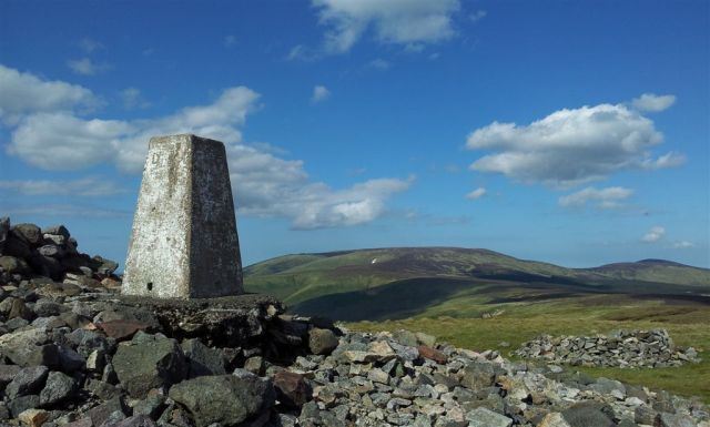
This section’s a bit of a slog and I’ve not yet found an actual path but luckily it’s relatively dry UNTIL you level out and see 2 lines of fenceposts which converge at the trig pillar at the top of Bloodybush Edge. This bit can be a bit squelshy. Bloodybush by name, green grassy lump by nature – and yet the views are rewarding sometimes as far as the pointy Lakes peaks.

Bloodybush Edge, it’s not bloody, not bushy & definitely not edgy – 2.20pm
After a cuppa & food sat on the plank of wood whilst leaning against the pillar (the only shelter from wind up here) you then cross the stile taking a line northwards towards The Cheviot. This descent is far more squelchfying so try to but follow the farmers quad tracks slightly zig zagging at times until you arrive down at the Salters Road, turning left through the gate westwards and eventually into the forest. A forest track comes up from the left then soon after leave the main forest road at a grassy path left which heads through the trees (the path goes WWS, the road goes WWN). First time here I missed this path and carried on up the road losing myself for an hour on a huge pointless coniferous loop. I was not happy.
The path continues in a fairly straight line through the trees before bending north west looking down at a valley clearing containing the Usway Burn. Heading straight down to a bridge over the burn you could be forgiven for not realising here lies that rarest of Cheviot things, a proper waterfall, Davidson’s Linn. Once over the bridge follow the stream left until near the top of the waterfall then you can veer right and down to the little sanctuary below. Excellent spot to paddle tired feet in summer, less so in winter 🙂

Davidson’s Linn waterfall & my boots – 3.30pm

Davidson’s Linn waterfall & no boots – 3.40pm
Reascend up to the path heading west into the trees and after 5 minutes you rejoin the forest road a T junction. Turn down left for 100 yards then turn off right along a firebreak containing an obvious path west which soon leaves the forest behind at long last. Continue north west past wooden signposts up to the Border Gate (Hexpethgate) on the Pennine Way. In decent weather I never tire of the view that opens up when you reach this spot.

The BORDER GATE on the BORDER RIDGE, looking north – 4.15 pm
Another plank of wood to sit on, another cuppa whilst gazing at the scenery. Then take the paved Border Ridge path south west up to wonderful Windy Gyle (past a false cairn top just to annoy you). Now I like Windy Gyle, I like it a lot.

Windy Gyle Summit Cairn, a Bronze Age burial mound – 4.40pm
Not the easiest top to photo but I like this one, with The Cheviot & Hedgehope on the horizon

The fabulous view north from WINDY GYLE, a favourite – 5.10pm
It’s easy to spend time up here gazing at the rolling distant views especially northwards into Scotland, the summit cairn sits on the Border and gives great shelter from the wind on Windy Gyle. I’ve sat up here many times, often alone and have to force myself to leave.
From here I normally take one of 3 routes back to the car, the quick one via Scotchman’s Ford, the longer diversion along the Pennine Way then down The Street (ancient Drovers Track), or the even longer one walking further along the Pennine Way to the Refuge Hut at Lamb Hill. I decided to try a 4th one for the first time, directly due south over Loft Hill. This starts off in crappy squelchy boggy heathery crap trying to follow the fence until suddenly open grassland is reached and you can at last lift your head up from concentrating on foot placing to admire the visual splendour ahead. Only then does this route make sense in keeping to the skyline and retaining height with views until virtually the final drop from Lamb Hill. I enjoyed this, not sure if it would be as much fun in ascent but that’s for another day.

Passing one of the Smelly Goats of the Cheviots
 descending Windy Gyle with Loft Hill ahead")
The vista (good word) descending Windy Gyle with Loft Hill ahead

Descending Loft Hill down to the farm at Rowhope
From Rowhope Farm it’s a short level walk following the Rowhope Burn back to Slymefoot and the car. Another great day in this area with no real difficulty except keeping dry feet, the rolling hills can very forgiving especially for my ancient knees 🙂 Just a few people were out in the hills in fact it can be a surprise when you see someone, mind my shorts & knee support combo is quite surprising:-)
- Start/Finish = Trows Rd End, Whitebridge, (Slymefoot) Car Park
- Time = 6 1/2 hrs (start 11.56am, finish 6.30pm) inc 40 mins on Windy G
- Distance = 13 miles (21 km)
- Height Ascent = 2,811 ft (857 m)
- Nearby Pubs etc = Barrowburn Tea Room & Rose & Thistle, Alwinton
- Date = Sunday 2nd June 2013, sunny & clear
- Thanks for reading
Other Routes From Slymefoot
- Barrowburn, Shillhope, Border Ridge, Windy Gyle & The Street – 12.3 miles
- Barrowburn, Border Ridge, Windy Gyle, Moxie Law & Lamb Hill – 15 miles
Click on the map below to link to the interactive route on Social Hiking.

Cheviots Route Map from Slymefoot & Barrowburn going anti clockwise


Pingback: A wintry weekend walk up Windy Gyle from Wedder Leap – Cheviots 9 miles) | MART IN THE HILLS